CatronCountyWalk

Catron County, New Mexico has about 400 miles of paved road, and we're planning to walk every mile of it ... eventually ...

Monday, January 23, 2006


Hard to convey the scale of these babies - one of them weighs as much as three Boeing 747s fully loaded, I think. Posted by Picasa

Picture by Elizabeth. Doesn't it look like they're on the move? Posted by Picasa

Sunday, January 15, 2006


Look up, look down, that lonesome road Posted by Picasa

And here it is, the Very Large Array. Posted by Picasa

The VLA is in Socorro County, our nextdoor neighbor. Posted by Picasa

Behind the sign you can just see the top of an old wooden windmill, possible relic of the cattledrive years early last century. Posted by Picasa

VLA in the distance

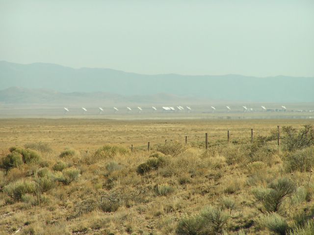
We started walking around 11:30, from the county line back towards Datil on Highway 60. The air was strangely hazy (due, perhaps to a cold air mass pressing down on top of a warm air mass and trapping all the dust raised by the wind of the last couple of days) and even though we were in a place where you could normally see for at least fifty miles in any almost any direction, visibility was obscured and led to some desolate landscape photos, as you will see if I can remember how to post pictures. The giant dishes of the Very Large Array were gathered in close formation, instead of being spread out across the plains, which was a little disappointing as well. Thinking I would be cold, I brought a very warm coat, which I wore for a mile or so and carried the rest of the way.

Total miles walked: 9.4! This is a big deal - it took me almost five months to get to the point where I could walk 9 or 10 miles comfortably last year, and this year I was able to do it on our second time out. (Total highway miles covered, 4.7)

Wildlife report: One bull elk jumped over a fence onto the highway, came to a stop, then continued on his way, soared over another fence and trotted away across a field.
One greater roadrunner made a mad dash onto the road and under the wheels of a passing truck, miraculously made it onto the other side without injury. High drama, as our hearts leapt into our throats.

Cloud report: In the distance, merging with the haze, low level cumulostratus. Directly above, deep blue sky with small smooth cumulus clouds scattered here and there. Not the typical fluffy cottonball cumulus clouds, but smooth and oddly shaped, looking like slightly melted spoonfuls of vanilla ice cream that have been licked at with a very large tongue.

Other sights/sounds/smells: We were passed by many small trucks and SUVs, one Hummer, many 18-wheelers, several enormous RVs, and several livestock trailers, the kind that leave in their wake the smell of shit and piss and fear.

Monday, January 09, 2006

2006!

It's been so long since I posted on a blog, it feels awkward and weird.

So, a recap of 2005:

Between January 1st and the end of May, we covered more than two-thirds of the paved roads in Catron County on foot. Then we took a nice long break.

Now it's 2006, and the Walk is back on.

January 1st, 2006 - drove one car to Datil, and walked from the intersection of Highway 12 and Highway 60, going east on 60, for a bit less than three miles. The sky was a deep and cloudless blue, the air was cold, the wind was fierce. Stopped for a quick snack of bread and cheese and Christmas fudge, then headed back west two miles and turned off onto a paved road that runs into Datil and ends back where we started, at the intersection of 12 and 60. Our total miles were 5.8, but ground covered actually came to only 3.8 miles. I was relieved to find out that 5.8 miles didn't almost kill me, as it would have when I started walking in January of 2005, although I did end up with a slight case of shinsplints and was slightly sore for a day or two.

We planned to walk again on January 8th, but I had a sore throat, a slight fever, and a weird rash of fever blisters on my upper lip.

Next scheduled walk will be Saturday January 14th, when we will try to walk from mile marker 80, where we turned around last time, all the way to the county line and the Very Large Array and back, about 9 or 10 miles total, assuming the weird rash of fever blisters has not migrated to my lower lip, or anywhere else, for that matter. I'll post pictures next time of the stretch between Datil and the VLA.